Available Translations:
Summary of GMEP results by Glastir Outcome
A wide range of results are now available from the GMEP project. These provide evidence of ongoing changes in Wales' Natural Resources. A subset of results has been agreed with the Welsh Government and the GMEP Advisory Group as high level indicators for the 6 Outcomes of the Glastir Scheme and are reported here. The six outcomes are:
- Combating climate change
- Improving water quality and managing water resources
- Improving soil quality and management
- Maintaining and enhancing biodiversity
- Managing landscapes and historic environment and improving public access to the countryside
- Woodland creation and management
GMEP activities have included; a national rolling field survey of 300 1km squares with an equal split of land in and out of scheme; new analyses of long term data from other monitoring programmes; development of new indicators; modelling to explore potential future outcomes; surveys to assess wider socio-economic benefits; and exploitation and development of novel technologies.
These indicators are included in the Headline Results below to give a broad summary of the significant findings of GMEP as either 'positive outcomes' or 'areas of concern or a need for further action'.
Headline Results: Glastir Impacts
GMEP was tasked with providing a baseline for assessing the future impacts of Glastir. Future field surveys will provide the main evidence for actual change in the six original intended Outcomes. To provide an early insight into likely future impacts on the six original Outcomes intended for Glastir, we exploited a set of models and accounting tools to project the likely impacts of management interventions for soil, water, biodiversity, climate change and woodlands.
Combating climate change
Positive Outcomes: Glastir Impacts
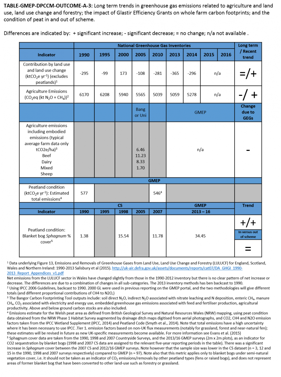
- 4.9% average reduction in greenhouse gas emissions per hectare across 15 farms in receipt of Glastir Efficiency Grants for which detailed repeat "carbon footprints" have been assessed using the Bangor carbon footprinting tool.
Areas for concern or further action needed: Glastir Impacts
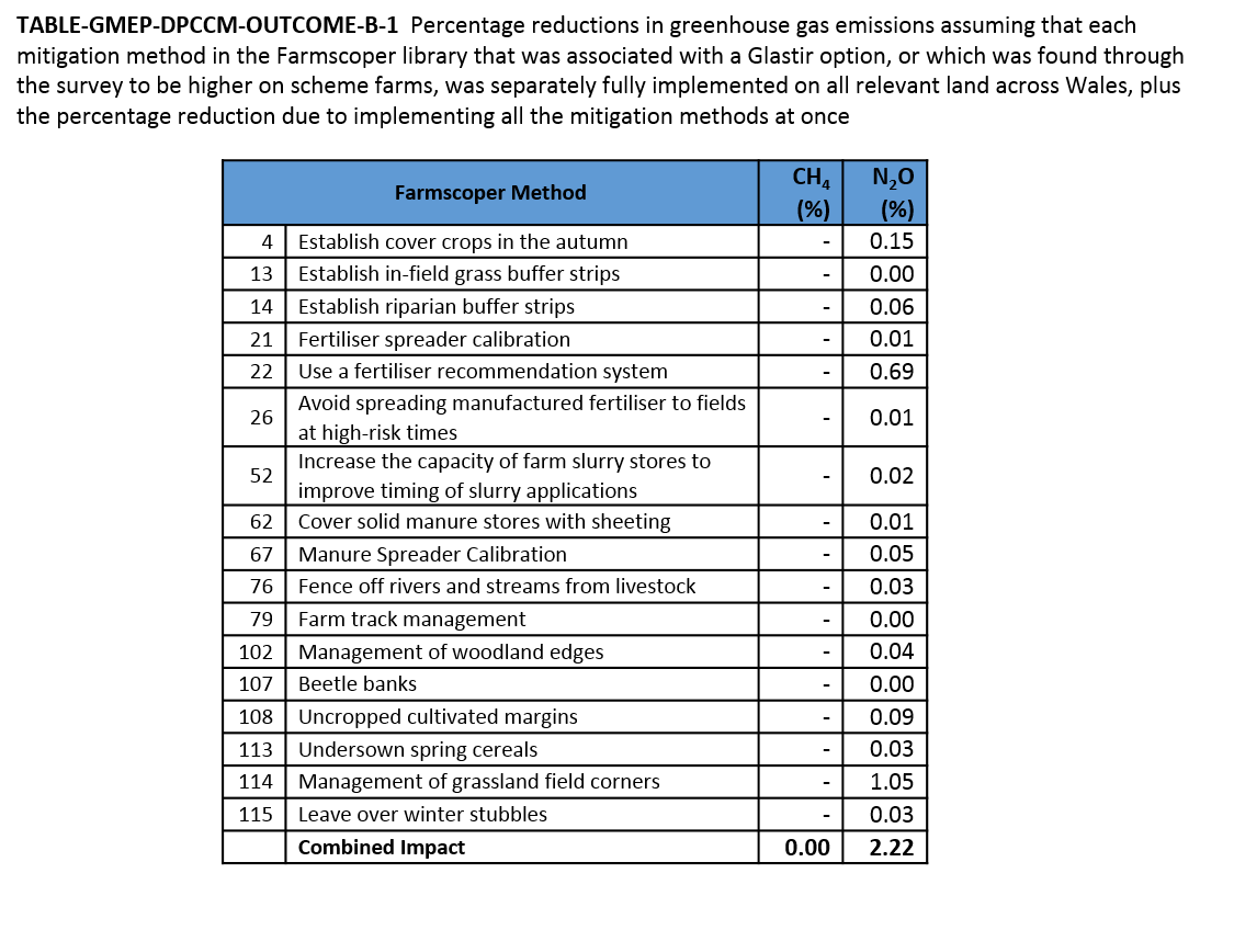
Modelling using the Farmscoper model suggest the impacts of Glastir agreements for methane and nitrous oxide emissions will result in reductions of 1.4% and 1.8% respectively for Glastir farms which scales to 0.6% and 0.8% for Wales as a whole. In Year 1 of GMEP, modelled estimates based on more ambitious estimates of potential land use change and reductions in animal numbers and fertiliser use for greenhouse gas emissions were 8-10%.
An increase of just 2.5 tonnes per year (0.1%) extra sequestration of carbon in vegetation and the top 1m of soils has been calculated using the LUCI model as a result of all woodland actions undertaken within Glastir reflecting the rather limited uptake of Glastir woodland grants.
Detailed findings: Glastir impacts
For more detail on data and findings related to Glastir impacts, visit the Resources page and download the GMEP Final Report or the GMEP Final Report Executive Summary.
Headline Results: National Trends
The GMEP 'Wider Wales' structured rolling field survey provides the control population for assessing future changes resulting from Glastir. One benefit of the structured sampling of the countryside used in this Wider Wales survey is that this control population also provides an unbiased national assessment of stock and condition of common habitats and species including woodland, soils, small streams and ponds. GMEP results can be linked to past trends to put the current observations into context.
Combating climate change
Positive Outcomes: National Trends
- None specified for now. Base line data are available for future assessments of Glastir impacts.
Areas for concern or further action needed: National Trends
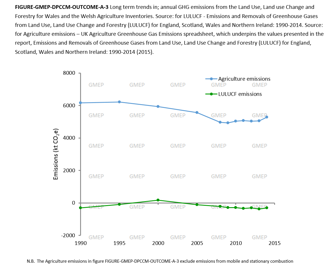
There has been a recent increase in greenhouse gas emissions from both the Agriculture Inventory and the Land Use, Landuse Change and Forestry (LULUCF) Greenhouse Gas inventory. The 14% reduction in agricultural emissions between 1990 and 2014 due to a 42% decline in fertiliser use has been reversed to a 4% increase between 2013-2014 due to increased nitrogen fertiliser use, and increased dairy cattle and sheep numbers. The decrease in the greenhouse gas sink of woodlands is due to ageing of the current resource and limited new planting.
There was a high variability of +/- 260% in the carbon footprint of lamb for slaughter which reflects both the high variability in land quality and the potential for management improvement
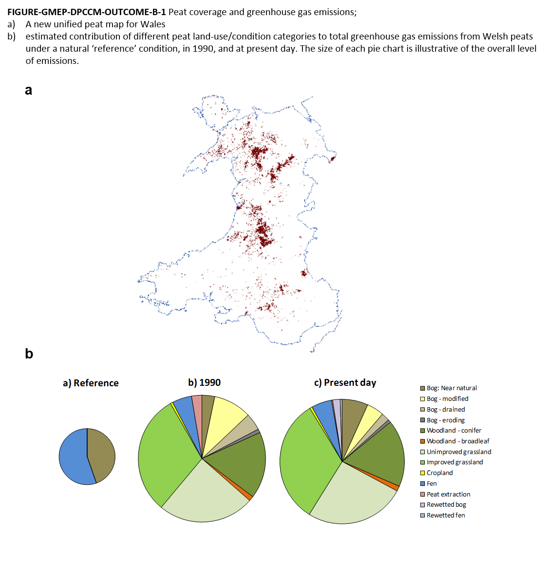
Based on a new 'unified' Welsh peat map developed within GMEP, peat soils are estimated to cover more than 90,000 ha of Wales (4.3% of the total land area) of which 75% is in upland areas, and 25% in lowland areas. Overall, around three quarters of the Welsh peat soil area is thought to have been impacted by one or more land-use activities, including drainage, overgrazing, conversion to grassland and afforestation. Of this area only 30% is in 'good condition' with 25% 'modified' into grassland and 10% into woodland. As a result of these activities, Welsh peat soils are currently estimated to be generating 'anthropogenic' emissions of around 400 kt CO2-equivalents per year (equating to approximately 7% of all Welsh transport-related emissions). This compares to an estimated natural 'reference' condition (i.e. if all the currently mapped peat area was natural bog or fen) of approximately 140 kt CO2-equivalents per year.
Detailed findings: National Trends
Further information on National Trends in high level GMEP indicators is available in the figures and tables below. For more detail on data and findings related to National Trends, visit the Resources page and download the GMEP Final Report or the GMEP Final Report Executive Summary.


